1952 U.S. Army Air Forces Aeronautical Map of Eastern Somalia (Cape Guardafui) 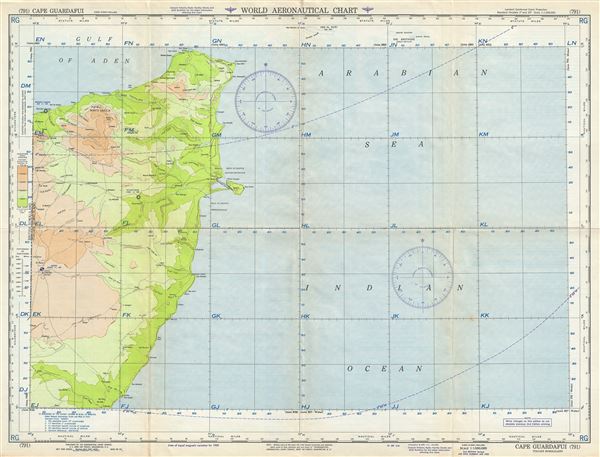 WE SELL ONLY ORIGINAL ANTIQUE MAPS - NOT REPRODUCTIONS Title: Cape Guardafui Italian Somaliland. Description: This is a scarce 1952 U.S. Army Air Forces aeronautical chart or map of eastern Somalia. It covers from Haylan south to Il Marodi, focusing on Cape Guardafui or Ras Asir, forming the apex of the Horn of Africa. The chart notes towns, roads, cities, rivers, lakes, topography and other data essential to the air pilot. Verso features legends and a world aeronautical chart index. This chart was published by the Aeronautical Chart Service, U.S. Army Air Forces, Washington D.C., and issued as chart no. 791. First issued in 1944, this is the second edition revised to April 1952. Size: Printed area measures 22 inches high by 29 inches wide. Condition: Very good. Minor wear and toning along original fold lines. Minor edge wear. Shipping: Shipping rates are not negotiable. Items are shipped within three business days of receiving payment. We are happy to consolidate shipping where possible. The following shipping options are available: 1. FedEx Overnight (45 USD). USA Only. Signature Required. Customs: International buyers are responsible for paying duty and taxes on delivery. DHL or FedEx will contact the buyer by telephone to arrange tax payment if it is levied. Duty varies by country and we cannot predict the amount you will be charged. Some countries are duty free, others are not. Typically, a customs duty and/or VAT tax will be assessed on all parcels to continental Europe. Sometimes duty or tax is due in China, but is seems very random. Hong Kong, Singapore, Korea, and Taiwan have never assessed duty on a map we shipped. Maps shipped to the UK should be duty free as educational materials, but from time to time duty of 5% is assessed incorrectly by the UK customs agents. Insurance: All shipments are insured privately against loss and damage. All of our shipments require a signature for insurance purposes. If you have any questions please feel free to email us through eBay. Other Services Conservation Framing: Geographicus recommends basic conservation framing services for any antique paper. We do not offer this service. |
