1786 Desnos and de la Tour Map of Lower Saxony and Upper Saxony, Germany 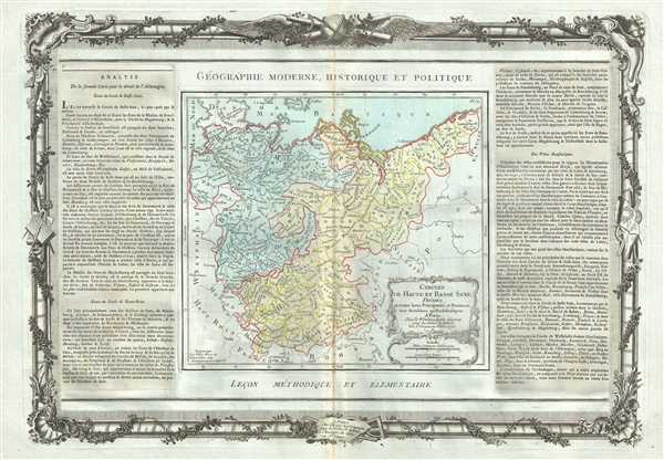 WE SELL ONLY ORIGINAL ANTIQUE MAPS - NOT REPRODUCTIONS Title: Cercles de Haute et Basse Saxe. Description: This is an attractive 1786 map of Upper Saxony and Lower Saxony, what is now central Germany, by the French Cartographer Louis Brion de la Tour. The map covers from Holstein south to Bohemia and Westphalia east to Poland. Renders the entire region in extraordinary detail offering both topographical and political information. The 'circles' of Germany are the 'imperial circles,' administrative units created for tax and defense purposes by the Holy Roman Empire, of which these areas were a part. The Napoleonic Wars would, of course, dissolve the Holy Roman Empire and lead to the consolidation of Germany in 1871. During the French Revolutionary Wars, the Hanoverian Duke and British King George III allied with the Prussians against Napoleon, which nonetheless did not prevent the French ruler from briefly invading and occupying the territory. In 1180 Duke Henry the Lion fell, and the medieval Duchy of Saxony dissolved. The Saxe-Wittenberg lands were passed among dynasties who took the tribal name Sachsen (Saxons) upstream as they conquered the lands of the Polabian Slavs further up the Elbe. The Polabian Slavs had migrated to this area of Germany in the second half of the first millennium A.D., and had been largely assimilated by the Holy Roman Empire by the time this map was made. Today, the German government recognizes some 60,000 'Sorbs,' or descendants of the Polabian Slavs, who have retained their language and culture. A beautifully engraved title cartouche adorns the top left quadrant of the map. To the left and right of the map are paste downs of French text with remarks and description of the map. Surrounding the whole is an elaborate decorative border featuring floral arrangements, surveying tools, elaborate baroque scalloping, and a winged globe. This map was issued as plate no. 32 in the most deluxe edition of Desnos’ 1786 Atlas General Methodique et Elementaire, Pour l’Etude de la Geographie et de l’Histoire Moderne. Size: Printed area measures 14.5 inches high by 20.5 inches wide. Condition: Very good. Minor toning along original centerfold. Minor spotting at places. Original platemark visible. Minor overall toning. Shipping: Shipping rates are not negotiable. Items are shipped within three business days of receiving payment. We are happy to consolidate shipping where possible. The following shipping options are available: 1. FedEx Overnight (45 USD). USA Only. Signature Required. Customs: International buyers are responsible for paying duty and taxes on delivery. DHL or FedEx will contact the buyer by telephone to arrange tax payment if it is levied. Duty varies by country and we cannot predict the amount you will be charged. Some countries are duty free, others are not. Typically, a customs duty and/or VAT tax will be assessed on all parcels to continental Europe. Sometimes duty or tax is due in China, but is seems very random. Hong Kong, Singapore, Korea, and Taiwan have never assessed duty on a map we shipped. Maps shipped to the UK should be duty free as educational materials, but from time to time duty of 5% is assessed incorrectly by the UK customs agents. Insurance: All shipments are insured privately against loss and damage. All of our shipments require a signature for insurance purposes. If you have any questions please feel free to email us through eBay. Other Services Conservation Framing: Geographicus recommends basic conservation framing services for any antique paper. We do not offer this service. |
