1770 Bonne Map of the East Indies (Java, Sumatra, Borneo, Singapore) 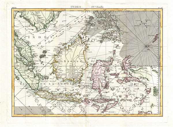 WE SELL ONLY ORIGINAL ANTIQUE MAPS - NOT REPRODUCTIONS Title: Indes IVe. Feuille. Description: A beautiful example of Rigobert Bonne's 1771 decorative map the East Indies. Covers from the Gulf of Siam (Gulf of Thailand) and Malacca (Malaysia) eastward to include parts of Sumatra, Java, Borneo, the Celebes, parts of Cambodia, the southern Philippine Islands, and New Guinea. Offers considerable detail of the region. Notes the Straight of Singapore (Det. de Sin Capura) and shows but does not label the island of Singapore. In Borneo, this map provides good detail along the Banjermassin or Barito River, detailing numerous villages and trading stations. Names Bali and Lombok as well as Batavia. Several of the southern islands are drawn with their southern shores ghosted in - suggesting an uncertain coastline. This is also the case with much of New Guinea (Nouvelle Guinee), which was largely unexplored well into the 19th century. Rhumb lines throughout. Arrows in the lower right show the direction of prevailing winds during the dry season and the monsoon season. A fine map of the region. Drawn by R. Bonne in 1771 for issue as plate no. D 26 in Jean Lattre's 1776 issue of the Atlas Moderne. Size: Printed area measures 12 inches high by 16.5 inches wide. Condition: Very good condition. Original centerfold exhibits minor toning. Blank on verso. Shipping: Shipping rates are not negotiable. Items are shipped within three business days of receiving payment. We are happy to consolidate shipping where possible. The following shipping options are available: 1. FedEx Overnight (45 USD). USA Only. Signature Required. Customs: International buyers are responsible for paying duty and taxes on delivery. DHL or FedEx will contact the buyer by telephone to arrange tax payment if it is levied. Duty varies by country and we cannot predict the amount you will be charged. Some countries are duty free, others are not. Typically, a customs duty and/or VAT tax will be assessed on all parcels to continental Europe. Sometimes duty or tax is due in China, but is seems very random. Hong Kong, Singapore, Korea, and Taiwan have never assessed duty on a map we shipped. Maps shipped to the UK should be duty free as educational materials, but from time to time duty of 5% is assessed incorrectly by the UK customs agents. Insurance: All shipments are insured privately against loss and damage. All of our shipments require a signature for insurance purposes. If you have any questions please feel free to email us through eBay. Other Services Conservation Framing: Geographicus recommends basic conservation framing services for any antique paper. We do not offer this service. |
