1946 Pictorial Map of Cape Cod, Massachusetts 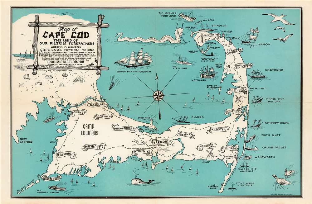 WE SELL ONLY ORIGINAL ANTIQUE MAPS - NOT REPRODUCTIONS Title: Map of Cape Cod the Land of Our Pilgrim Forefathers wherein is Indicated Cape Cod's Fifteen Towns of Provincetown, Reruro, Wellfleet, Eastham, Orleans, Brewster, Chatham, Harwich, Dennis, Yarmouth, Barnstable, Sandwich, Bourne, Mashpee, Falmouth. Actual duplications of many shipwrecks and landmarks. Designed and Planned by Edward Rowe Snow. Drawen by Ugo Donofrio. 1946. Description: A charming 1946 pictorial map of Cape Cod and its towns, created by New England author and historian Edward Rowe Snow. A lover of all things piratical and nautical, Snow brusquely marks out the towns of Cape Cod with banners, but indulges himself in his depictions of ships and shipwrecks, sea birds, whales and even a sea monster menacing Provincetown. The shipwrecks are not generic, but rather are specific, named ships ranging from the Pirate ship ‘Whidah’ (Whydah Gally, a slaver and pirate ship sunk in 1717) to Submarine S-4 (SS-109, a U.S. Submarine sunk in 1927). Camp Edwards (a major WWII training ground) is marked on the map, as is Hyannis Airport. Publication History and CensusThis piece is scarce on the market. It is neglected in institutional collections: it appears only in the Harvard University library and the Family History Library in Salt Lake City. We see only one example in auction records from 2017. |
2. FedEx Ground or Home Delivery (15 USD). USA Only. 1 - 10 days. If your address is a P.O. Box and cannot ship FedEx we will ship USPS Priority and, while we ship promptly, recent postal personnel cutbacks mean that delivery may take time. Signature Required.
3. FedEx International or DHL International EXPRESS (45 USD).
4. We can use your FedEx Account.
Antique Map Restoration: Geographicus can repair and restore your antique map. Services include deacidification cleaning flattening and backing.
BEWARE anyone attempting to contact you, from a different eBay account, claiming to represent Geographicus Antique Maps. My eBay handle is GeographicusMaps. If you are contacted by email by someone offering you my items, please call me directly to be certain you are not dealing with a con artist.
