|
This color map of District of Alaska (as it was known prior to 1912 when it was incorporated and recognized as the Territory of Alaska) was engraved and printed by the L.L. Poates Engraving Company, New York, to accompany a set of reference material published between 1891 and 1896. Alaska did not attain statehood until 1958, so this is among the earliest organized maps of the region from 1884-1912 known as the District of Alaska. There were few Western settlements in the region, and very few cities or villages are identified on this map (I could find only four--see below), but naval ports are located, as well as military forts (mostly in the Canadian region east of the border, which would become known as the Yukon Territory within a decade). Capes, Rivers, Lakes, Mountains, and other topographical features are located on this map, as well as some areas identified simply as "Unexplored."
There is also an inset map of the Aleutian Islands located in the top-right portion.
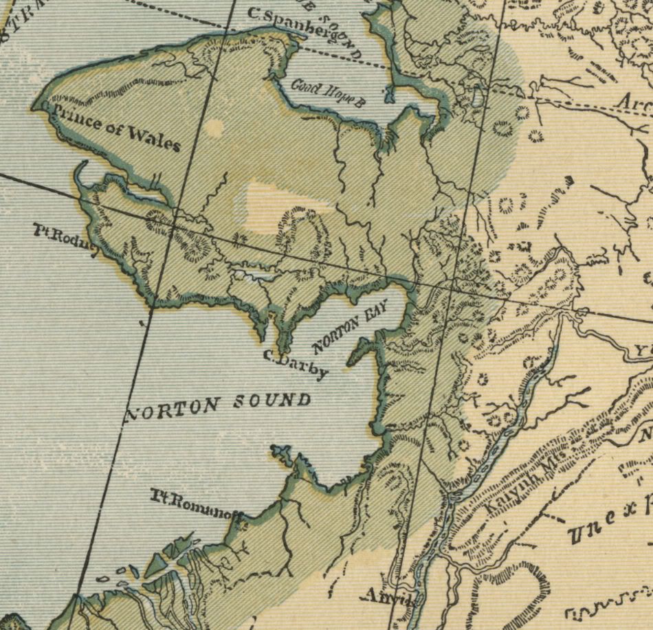
Of interesting note on this map: One of the very few cities located on this map is Anvik (see closeup photo), on the Yukon River near the Norton Sound region. At that time, Anvik's population (191, according to the 1890 Census) actually outnumbered that of Saint Michael (101, according to 1890 Census), so St. Michael is not labeled on the map. Interestingly, nearby Nome is also not labeled on the map, although it was a more more populous settlement at the time. This was prior to the Klondike Gold Rush population boom (1898-1899) occurred, following the discovery of gold on Anvil Creek. This gold rush brought thousands of people to the region at the turn of the 20th century, and literally put villages like St. Michael and Nome on the next maps (see 1907 Alaska map, and others).
Cities located on this map
Anvik
Chilkoot Village (a village inhabited by three clans of the Tlingit culture)
Juneau ("Juneau City" on the map)
Sitka
The map is printed on medium weight paper, blank on the reverse and with a fold in the center (as issued). The sheet size is 9.75" x 11.75". The bordered map area is about 8" x 10" with blank margins of between 1/2" to 1 inch all the way around to allow convenient matting.
This is a very attractive older map and would look beautiful matted and framed. If you want a detailed map showing the state as it was 130 years ago, when much of it was still unexplored prior to the Gold Rush, this is a good one.
This map is not dated on the face, although all of the other state maps from this source do feature a copyright statement of "COPYRIGHT, 1891, by Dodd, Mead & Company." The lack of a date on the face of this map is likely a function of it being merely a territory in 1891, with much of the region yet unsettled and uncharted. Subsequent maps (see 1907 Alaska map, and others) do feature a dated copyright statement, (along with quite a few more labeled settlements and mines!), but this map does not. Feel free to compare the images in this listing with those of other state maps from my 1891 collection; you can see that they are from the same source, despite the lack of copyright on the map itself.
Please check my listings for other possible versions of this map. One of the delightful and interesting results of the engraving and ink transfer process in lithography is that there can be color variants of the maps which look distinct from each other, even though they were produced by the same engraved plates on the same press. This may be a result of additional passes by one color or another, subtle differences in the ink tone, varying pressure from the pressing of the plates, slight variation in the position of each color plate, or other choices made by the engravers or the printers. The result is that each map's appearance is truly unique.
1) The first image shows the map cropped without its full margins. The full, blank margins are actually between 1/2" and 1" all the way around.
2) The second image is a closeup of the area around Norton Sound , to show the quality and detail of the engraving. Point Romanof is labeled, near Stuart Island, which is not labeled. Only one city, Anvik (population 191, according to the 1890 Census!), is located in this closeup, on the Yukon River.
|