1949 War Office Map of Hong Kong 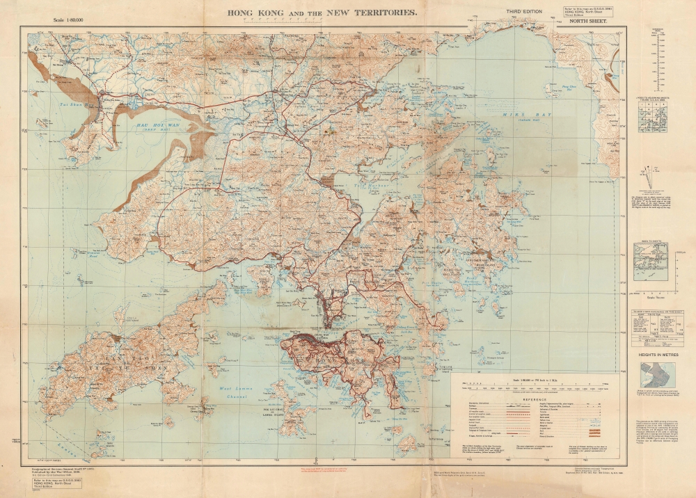 WE SELL ONLY ORIGINAL ANTIQUE MAPS - NOT REPRODUCTIONS Title: Hong Kong and the New Territories. North Sheet. Description: This is a 1949 British War Office map of Hong Kong, Kowloon, and the New Territories. The map depicts the region from China to Po Toi Island and from Tai Shan Bay and Lan Tao to the Dapeng Peninsula and Bias Bay. Towns, and villages are labeled, and Victoria and Kowloon City are illustrated in detail, down to individual streets and buildings. All weather roads stand out even more from the topographic background covering the entire map, making what is presumably the most accessible road network the first element registered by a viewer. Various other grades of road are also illustrated here, each of which are indicated by a different notation. Smaller islands throughout the region are labeled, along with bays, rivers, harbors, and hills. A legend is situated in the lower right corner. Post War Hong KongAfter the announcement of Japan's unconditional surrender on August 15, 1945, it took nearly two weeks for a British occupation force to reclaim their lost colony. It would not be long before the Chinese Nationalists (Kuomintang) and the Chinese Communists began fighting a ruthless civil war that lasted until 1949. 1949, as it turns out, was also a critical year in the history of British hegemony in Hong Kong, as the British government finally made the definitive decision to defend Hong Kong instead of abandoning it to the victorious Chinese Communist Party. The British believed that by taking a stand in defense of the Colony, their firm position may serve as a deterrent against Chinese Communist aggression against the colony, that it may bring uncertain parts of the local population to the British side and reduce the possibility of internal security threats, and that holding Hong Kong would strengthen the anti-Communist position in Southeast Asia. Although the true commitment of the British to holding Hong Kong, it is true that Hong Kong was reinforced to a garrisoned troop strength to 30,000 soldiers, plus tanks, land-based fighter aircraft, and a large naval presence, including an aircraft carrier. Communist forces did mass along the border with the New Territories in October 1949, but never moved further, and eventually withdrew.Census and Publication HistoryThis map was produced and published by the War Office in 1949. It is the 3rd edition. Per the OCLC, this map is part of six institutional collections. It is scarce on the private market.Size: Printed area measures 29 inches high by 40.25 inches wide. Condition: Very good. Wear and toning along original fold lines. Verso repairs to fold separations. Soiling. Blank on verso. Items are shipped within three business days of receiving payment. 1. USA Only. Signature Required. Customs: International buyers are responsible for paying duty and taxes on delivery. DHL or FedEx will contact the buyer by telephone to arrange tax payment if it is levied. Duty varies by country and we cannot predict the amount you will be charged. Some countries are duty free, others are not. Typically, a customs duty and/or VAT tax will be assessed on all parcels to continental Europe. Sometimes duty or tax is due in China, but is seems very random. Hong Kong, Singapore, Korea, and Taiwan have never assessed duty on a map we shipped. Maps shipped to the UK should be duty free as educational materials, but from time to time duty of 5% is assessed incorrectly by the UK customs agents. Insurance: All shipments are insured privately against loss and damage. All of our shipments require a signature for insurance purposes. If you have any questions please feel free to email us through eBay. Other Services Conservation Framing: Geographicus recommends basic conservation framing services for any antique paper. We do not offer this service. |
