Approaches Holyhead Bay Holy Island Map Nautical Chart 28x40 inches 1967
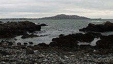
Holy Island (Welsh: Ynys Gybi, 'the island of (Saint) Cybi') is an island on the western side of the larger Isle of Anglesey, Wales, from which it is separated by the Cymyran Strait. It is called "Holy" because of the high concentration of standing stones, burial chambers, and other religious sites on the small island. The alternative English name of the island is Holyhead Island. According to the 2011 UK Census, the population was 13,659, of whom 11,431 (84%) lived in the largest town, Holyhead.
Approaches Holyhead Bay Holy Island Map Nautical Chart 28x40 inches 1967
Holy Island (Welsh: Ynys Gybi, 'the island of (Saint) Cybi') is an island on the western side of the larger Isle of Anglesey, Wales, from which it is separated by the Cymyran Strait. It is called "Holy" because of the high concentration of standing stones, burial chambers, and other religious sites on the small island. The alternative English name of the island is Holyhead Island. According to the 2011 UK Census, the population was 13,659, of whom 11,431 (84%) lived in the largest town, Holyhead.
|
|
|
|
|

Attention Sellers - Get Templates
Image Hosting, Scheduling at Auctiva.com. 


