
1. ✅US Stock✅ONLY Left 2pcs✅Ship from CA/KY within 12hrs, Pls take opportunity. Any questions pls send ebay message to us.
2. ONLY Free shipping to USA mainland address. Other countries will clear customs on their own and needs to pay for the international shipping fee.
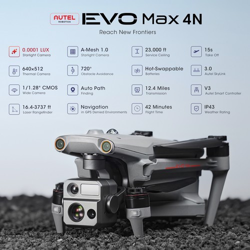
Reach New Frontiers
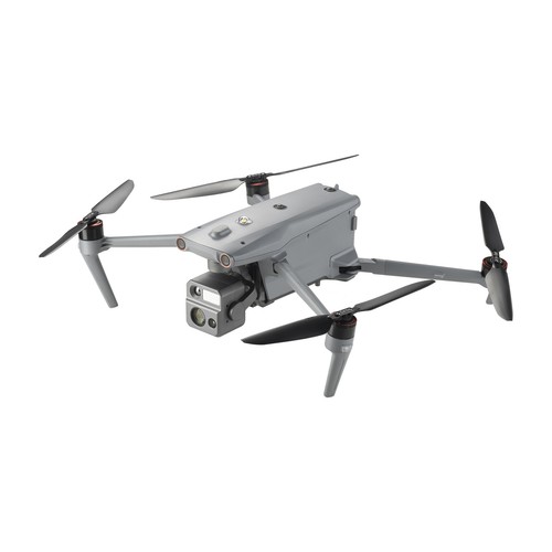
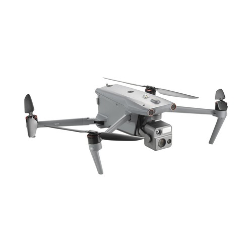
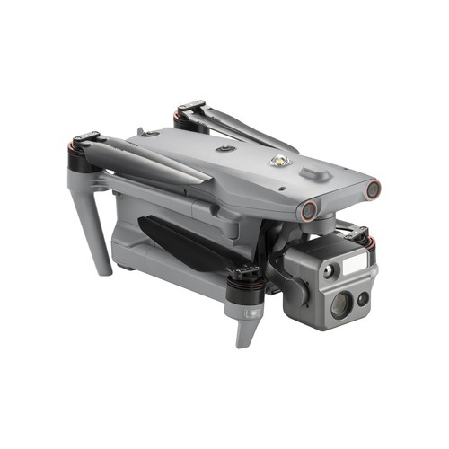
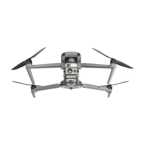
The Autel EVO Max 4N brings powerful technologies and advanced autonomy to professional drone users. The EVO Max 4N assesses complex environments to create real-time 3D flight paths for unparalleled obstacle avoidance. Advanced sensors make flight in GPS unavailable areas possible and the incredible new thermal payload unlocks new object identification and tracking scenarios. With a foldable weather-resistant design - the Autel EVO Max 4N is as portable as it is capable.

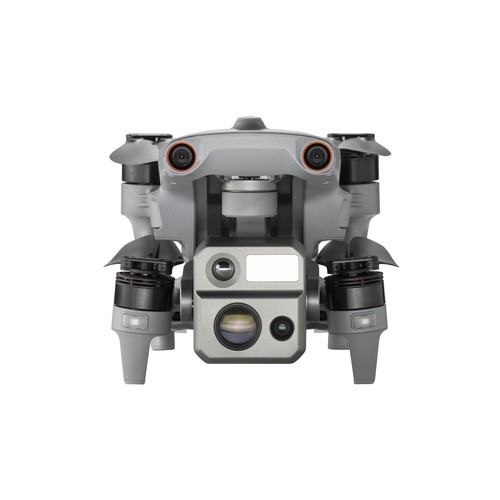
Autel EVO Max 4N - Explore the Night
The Autel EVO Max 4N is the next generation of intelligent, agile drones, equipped with 720-degree obstacle avoidance and A-Mesh 1.0 networking support. This commercial drone is designed for night operations, featuring starlight night vision, zoom, thermal cameras, and full laser ranging capabilities. The EVO Max 4N's exceptional starlight camera allows it to operate in lighting conditions as low as 0.0001 Lux, delivering unparalleled performance in the dark. This makes it ideal for night surveys, emergency responses, and other critical missions that require superior visibility. With its advanced features and capabilities, the Autel EVO Max 4N is the ultimate night-ops-ready drone for commercial applications.
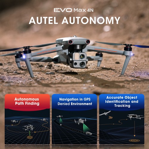
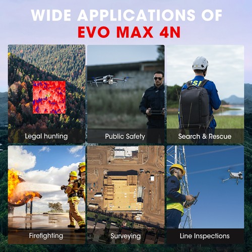
Autonomous Path Finding The Autel EVO Max 4N is powered by Autel's advanced Autonomy Engine, which collects surrounding environmental data and plans 3D flight paths through complex environments like mountains, forests, and buildings. This drone is ideal for a wide range of commercial applications, including rapid 3D scene reconstruction, public safety overwatch, industrial inspection, and land surveying.

Navigation in GPS Denied Environment Advanced sensors allow the EVO Max 4N to navigate within hardened structures, underground, or in environments without GPS.

Accurate Object Identification and Tracking The EVO Max 4N uses Autel's AI recognition technology to automatically identify and lock onto different types of targets such as heat sources, moving people, or vehicles. This enables the drone to achieve high-altitude tracking and data collection for law enforcement and other applications where reliable, real-time surveillance is crucial.

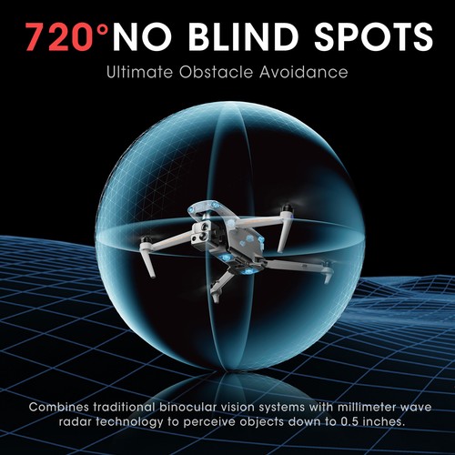
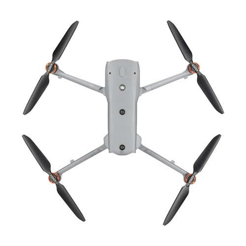
No Blind Spots
Ultimate Obstacle Avoidance
The EVO Max 4N is a unique commercial drone that combines traditional binocular vision systems with millimeter wave radar technology. This innovative combination enables the onboard Autel Autonomy Engine to detect objects as small as 0.5 inch, removing blind spots and allowing for operation in low light or rainy conditions.
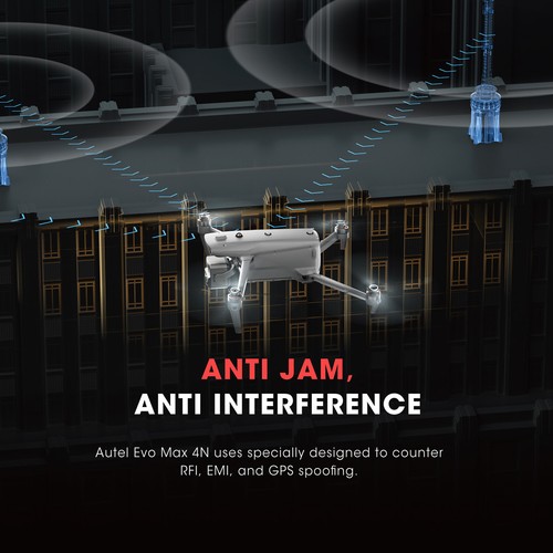
Anti Jam, Anti Interference
The EVO Max 4N is equipped with advanced flight control modules and algorithms that are specifically designed to counter RFI, EMI, and GPS spoofing. This feature allows the drone to fly confidently near power lines, critical structures, and in complex areas, making it an ideal tool for industrial inspections, emergency response, and other critical operations.
Weather Rating-IP43
The EVO Max 4N has an IP43 Ingress Protection rating, which means that it is protected against solid objects greater than 1mm in diameter and against sprays of water up to 60 degrees from the vertical. This makes the drone more durable and able to withstand challenging weather conditions, making it ideal for use in a wide range of applications.
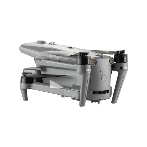
Platform Capability
EVO Max 4N redefines portability with its powerful platform and all weather design.
42 mins Max. Flight Time 23,000 ft Service Ceiling 12.4 miles Image Transmission Range 27 mph* Max. Wind Resistance

Hot-Swappable Battery
The Autel EVO Max 4N features a hot-swappable battery system, allowing for extended flight times without any downtime. This innovative system enables users to easily swap out batteries while the drone is still in operation, thereby ensuring that there is no interruption to operations and making it ideal for use in time-critical applications where every second counts.
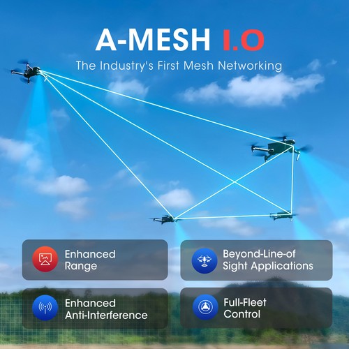
A-Mesh 1.0
The Drone Industry's First Mesh Networking Technology
EVO Max 4N features the new A-Mesh system, enabling drone-to-drone autonomous communication, connection, and collaboration.

Strong Anti-Interference The EVO Max 4N can communicate seamlessly with other drones in the vicinity, unlike a traditional chain structure. If a single drone fails or exits unexpectedly, the entire system will independently self-organize and continue to relay critical information.

Beyond-Line-of-Sight Applications The A-Mesh system in the EVO Max 4N allows multiple aircraft in the surrounding area to serve as relay points, significantly enhancing the effectiveness of operations beyond visual line of sight (BVLOS).
Full-Fleet Control The EVO Max 4N offers the capability to control multiple drones autonomously, either by a single pilot or by a group of pilots working simultaneously, with or without LTE coverage.

Enhanced Range Communication modes can be placed statically on hills or poles to provide full coverage to an area, or a swarm of drones can provide mobile communication points to extend the coverage of the entire group.
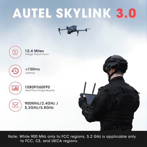
Autel SkyLink 3.0
The EVO Max 4N SkyLink 3.0 system comes with 6 antennas, 4 frequency bands, AES-256 encryption*, and optional 4G integration* to provide users with the most advanced flight capabilities ever in an EVO.
12.4 miles Image Transmission Distance <150ms Latency 1080p/60fps Real-Time Image Quality 900MHz/2.4GHz/5.2GHz/5.8GHz** Frequency Bands

This feature will be available in a future update. **5.2GHz is only applicable for FCC, CE, and UKCA regions. 900MHz is only applicable for FCC regions.
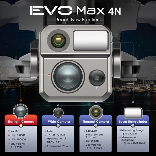
Mission Ready Payload
The payload integrates wide-angle camera, zoom camera, thermal camera and a laser rangefinder for all data capture needs and critical decision making.
As low as 0.0001 Lux operate in lighting conditions Auto ISO100-ISO450000 Super Sensitive Mode 50MP Wide Camera 1/1.28 CMOS Wide Camera Sensor 640x512 Thermal Resolution 5m to 1.2km Laser Rangefinder Measuring Range

Chase the Heat and Explore the Night
Autel Enterprise App Platform
The Autel Enterprise App has been specifically designed for industrial applications, with a brand-new interface that streamlines operation and enhances usability. With additional features and semi-autonomous modes, the app maximizes the EVO Max 4N's mission capability, enabling efficient and effective operation in a wide range of scenarios.

Smart Features

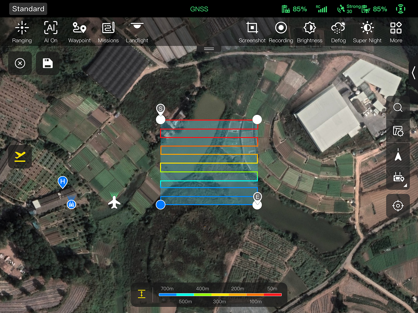
3D Map Planning Plan, create, and execute 3D waypoint mission plan on a 3D map.

Quick Mission* Temporary quick missions can be created while executing other missions, and multiple sub-missions can be stacked for enhanced flexibility.

Mission Reproduction* With this feature activated, fly a manual or semi-autonomous mission, or string multiple missions together. The EVO Max4N will automatically record the camera angles and replicate the mission you just flew.
Multiple Mission Types
The Autel Enterprise App offers a range of autonomous and semi-autonomous mission planning capabilities for a variety of applications, including public safety, inspection, and surveying.

Spiral Mission* Supports helical flight search in a designated area for SAR.
Automatic Mission Generation And Data Capture * Perform vertical surveys for building facades, open pit walls, and towers.

Corridor Mission* Supports intuitive and effective corridor mission planning for roads, rivers, pipelines, power lines and other narrow,large-scale terrain.

Polygon Mission Supports one-click automatic generation of polygon flight areas.

Terrain Follow* Maintain relatively constant altitude from the ground for uneven or sloped terrain.

Rectangular Mission Supports one-click automatic generation of a rectangular flight area.
Data Security
Privacy Protection: Data involving user and aircraft information, including flight logs, locations, and account information can only be physically accessed via the aircraft locally.
Encrypted Data Storage: Supports AES-256 encryption for photos, videos, and flight logs, are password-protected.

Enhanced Live-View
Multi-channel Projection Screen* Supports simultaneous output of RGB, infrared, night vision, and wide-angle images. 
AR Scene* Geo-location data and other aircraft location info detected by ADS-B can overlay on real-time map, which is convenient for users to confirm the drone's location and avoid airborne risks. 
Complete Remote Operations System
Used with the EVO Nest, the EVO Max series supports all-weather auto piloting for scenarios such as substations, industrial parks, and rooftops.
Autel EVO Max 4N Package List
| Aircraft | x1 |
| Battery | x1 |
| Gimbal Cover | x1 |
| 64GB MicroSD Card | x1 |
| Battery Charger & Power Cable | x1 |
| Clockwise Propellers | x3 |
| Counter-Clockwise Propellers | x3 |
| Screwdriver | x1 |
| Smart Controller V3 | x1 |
| Smart Controller Lanyard | x1 |
| Smart Controller Cover | x1 |
| Pair of Joysticks | x1 |
| RC Charger | x1 |
| RC Charging Cable | x1 |
| Data Cable | x1 |
| Manual | x1 |
| Quick Start Guide | x1 |
| Packing List | x1 |
| Rugged Case | x1 |
Specifications

EVO Max 4N Weight 3.62 lbs (1641g, battery and gimbal included) Max. Takeoff Weight 4.41 lbs (1999 g) Dimensions 562*651*147 mm (unfolded, incl. propellers)
318*400*147 mm (unfolded, excl. propellers)
257*145*131 mm (folded, excl. propellers)Diagonal Wheelbase 1.53 ft (466mm) Max Ascent Speed 8m/s Max Descent Speed 6m/s Max Horizontal Speed (windless near sea level) 23m/s
*Maximum speed in Ludicrous Mode is 19m/s when operating in EU regions.Max Service Ceiling Above Sea Level 13,124ft (4000m) Max Flight Time (windless) 42 mins Max Hovering Time (windless) 38 mins Max Wind Resistance 27mph*
*Takeoff and landing can withstand wind speeds up to 27 mph (12 m/s).IP Rating IP43 Max Tilt Angle 35° Max Angular Velocity Pitch: 300°/s; Yaw: 120°/s Operating Temperature -4°F to 122°F (-20℃ to 50℃) Internal Storage 128GB internal storage, with 64GB of available space* (Remaining available space will vary with different firmware versions) Operating Frequency 2.4GHz/5.8GHz
5.2GHz (only applicable for FCC, CE, and UKCA regions).
900MHz (only applicable for FCC regions).GNSS GPS+Galileo+BeiDou+GLONASS Transmitter Power (EIRP) 2.4GHz: <30dBm (FCC), <20dBm(CE/SRRC/MIC)
5.8GHz: <27dBm (FCC/SRRC), <14dBm (CE)
5.15-5.25GHz: <23dBm (FCC/CE)
902-928MHz: <30dBm (FCC)
5.65-5.755GHz: <27dBm (MIC)Hovering Accuracy Vertically:
±0.1 m (when vision systems working normally);
±0.5 m (when GNSS working normally);
Horizontally:
±0.3 m (when vision systems working normally);
±0.5 m (when GNSS working normally);Wi-Fi Protocol 802.11a/b/g/n/ac/ax
Support 2 x 2 MIMO Wi-FiWi-Fi Operating Frequency 2.400 - 2.4835 GHz;
5.150 - 5.250GHz (CE/FCC/MIC);
5.725 ‒ 5.850 GHz*(Except MIC)Wi-Fi Transmitter Power (EIRP) 2.400 - 2.4835 GHz
FCC:<30dBm; CE/SRRC/MIC:<20dBm
5.150 - 5.250GHz
FCC/CE/MIC<22dBm
5.725 ‒ 5.850 GHz
FCC/SRRC: <21dBm
CE: <14dBmMechanical Range Pitch: -135° to 45°
Yaw: -45° to 45°
Roll: -45° to 45°Controllable Range -90° to 30° Stable system 3-axis mechanical gimbal (pitch, yaw, roll) Max Control Speed (pitch) 200º/s Angular Vibration Range <0.005° Sensor 1/2" CMOS, Effective pixels: 48M Lens Focal length: 11.8-43.3mm (35mm, equivalent: 64-234mm)
Aperture: f/2.8-f/4.8
Focusing distance: 5m ~ ∞Exposure Compensation ±3EV 0.3EV/step ISO Range Normal Mode:
Auto: ISO100 ~ ISO6400
Manual:
Photo: ISO100 ~ ISO12800
Video: ISO100 ~ ISO6400Shutter Speed Photo: 8s ~ 1/8000s
Video: 1s ~ 1/8000sMax Photo Size 8000×6000 Max Video Resolution 7680×4320 Thermal Imager Uncooled VOx Microbolometer Lens FOV: 42°
Focal length: 13mm
Aperture: f/1.2
Focusing Distance: 6m ~ ∞Infrared Temperature Measurement
Accuracy±3℃ or reading ±3% (using the larger value) @ambient temperature range from -4℉ to 140℉ (-20℃~60℃) Video Resolution 640×512@25FPS Photo Size 640×512 Pixel Pitch 12 um Temperature Measurement Method Center measurement, pot measurement, rectangular measurement Temperature Measurement Range -4℉ to 302℉, 32℉ to 1022℉ (-20°C to 150°C, 0 to 550°C) Temperature Alert High and low temperature alarm thresholds, reporting coordinates and temperature values Palette White Hot/Black Hot/Searing/Rainbow/Grey/Ironbow/Cold and Hot Sensor Effective Pixels: 2.3M Lens Focal Length: 35mm (equivalent 41.4mm)
FOV:52°
Zoom Range: 1-8x, supports linkage zoomISO Range Auto: ISO100-ISO450000
Super Sensitive Mode: Auto ISO100-ISO450000Camera Modes Single shot (default), long press for continuous shots Photo Format JPG Photo Resolution 1920×1200 Video Format MP4 Video Resolution 20Mbps (1920×1200 P30) HDR Video Auto Video Output Super Sensitive Mode: 1920×1200 P30 Sensor Uncooled VOx Microbolometer Lens FOV:61°
Focal length: 9.1mm
Aperture: f/1.0
Focusing Distance: 2.2m ~ ∞Infrared Temperature Measurement Accuracy ±3℃ or ±3% of reading (using the larger value)
@ ambient temperature range from -4℉ to 140℉ (-20℃-60℃)Video Resolution 640×512@30FPS Photo Size 640×512 Pixel Pitch 12um Temperature Measurement Method Center measurement, pot measurement, rectangular measurement Temperature Measurement Range -4℉ to 302℉, 32℉ to 1022℉ (-20°C to 150°C, 0 to 550°C) Temperature Alert High and low temperature alarm thresholds, reporting coordinates and temperature values Palette White Hot/Black Hot/Searing/Rainbow/Grey/Ironbow/Cold and Hot Sensor 1/1.28 CMOS, Effective pixels: 50M Lens FOV: 85°
Focal length: 4.5 mm (equivalent: 23 mm)
Aperture: f/1.9
AF motor: PDAF focusExposure Compensation ±3EV 0.3EV/step ISO Range Auto:
Photo: ISO100~ISO6400
Video: ISO100~ISO64000 (Night scene mode: up to ISO64000)
Manual:
Photo: ISO100~ISO12800
Video: ISO100~ISO6400Shutter Speed Photo: 8s ~ 1/8000s
Video: 1s ~ 1/8000sMax. Video Resolution 3840×2160 Photo Size 4096*3072 Measurement Accuracy ± (1 m + D×0.15%)
D is the distance to a vertical surfaceMeasuring Range 5m to 1.2km Operating Frequency 2.4G/5.8G/900MHz*
*900MHz is only applicable for FCC regions.Max Transmission Distance
(unobstructed, free of interference)12.4 miles/20km (FCC), 4.9 miles/8km (CE) Independent Networking Autel Smart Controller V3 Transmitter Power (EIRP) 2.4GHz: <28dBm (FCC), <20dBm (CE/SRRC/MIC)
5.8GHz: <28dBm (FCC/SRRC), <14dBm (CE)
5.15-5.25GHz: < 23dBm(FCC/CE)
902-928MHz: <30dBm (FCC)
5.65-5.755GHz: <27dBm (MIC)Frequency 60GHz/24GHz*
*Please fly safely and comply with your local laws and regulations to use 60GHz.Sensing Range 60GHz Radar:
Upward: 0.98-787.4in (0.3-20m)
Downward: 5.9-3149.6in (0.15-80m)
Forward and Backward: 0.98-98.43ft (0.3-50m)
24GHz Radar:
Downward: 2.62-39.4ft (0.8-12m)FOV Horizontal (6dB): ±60°/±22° (24G/60G)
Vertical (6dB): ±30°/±20° (24G/60G)Operating Environment The 60GHz millimeter-wave radar sensing system supports all-weather obstacle avoidance for glass, water, wires, buildings, and trees. Its obstacle avoidance distance varies with the obstacle's ability to reflect electromagnetic waves and its surface size.
The 24Ghz millimeter-wave radar supports downward sensing, and its sensing range varies by the ground material. For example, the sensing range of cement ground is 12 meters, and the sensing range of grass with a thickness of more than 3cm is less than 6 meters.Obstacle Sensing Range Forward: 19.7-1220.5in (0.5-31m)
Backward: 19.7-984.3in (0.5-25m)
Sideward: 19.7-1023.6in (0.5-26m)
Upward: 0.66-85.3ft (0.2-26m)
Downward: 0.98-75.5ft (0.3-23m)FOV Forward/Backward Sensor: 60°(H), 80°(V)
Upward/Downward Sensor: 180°(sideward), 120°(forward & backward)Operating Environment Forward, Backward, Sideward, Upward: The surface has rich texture, under sufficient lighting environment (>15 lux, normal indoor fluorescent lighting environment)
Downward: The surface is a diffuse material with a reflectivity >20%
(walls, trees, humans, etc.), under sufficient lighting environment (>15 lux, normal indoor fluorescent lighting environment)Sensing Range Forward & Backward: 11.8-1968.5in (0.3-50m)
Sideward: 19.7-1023.6in (0.5-26m)
Upward: 0.66-85.3ft (0.2-26m)
Downward: 0.49-262.5ft (0.15-80m) (60Ghz radar)FOV Forward/Backward Sensor: 80°(H), 120°(V)
Upward/Downward Sensor: 180°(sideward), 120°(forward & backward)Operating Environment Forward, Backward, Upward, Downward: supports all-weather obstacle avoidance for glass, water, twigs, buildings and high voltage lines. At least one of the 2 conditions should be met: sufficient lighting or the obstacle has strong reflection ability to electromagnetic waves.
Sideward: The surface has rich texture, under sufficient lighting environment (>15 lux, normal indoor fluorescent lighting environment)Screen 7.9 inch, 2000nits max. brightness, 2048*1536 resolution Battery Capacity: 5800mAh
Battery Type: Intelligent Lithium Ion Battery
Voltage: 11.55V
Energy: 67Wh
Charing time: 120minsOperating Time 2.5 hours (Max. brightness)
4.5 hours (50% brightness)Max Transmission Distance
(without interference)12.4 miles/20km (FCC), 4.9 miles/8km (CE) IP Rating IP43 Storage 128G GNSS GPS+GLONASS+Galileo+Beidou Operating Temperature -4°F to 104°F (-20℃ to 40℃) Wi-Fi Protocol WiFi Direct, Wi-Fi Display,
802.11a/b/g/n/ac
Support 2 x 2 MIMO Wi-FiOperating Frequency 2.400 - 2.4835 GHz;
5.150 - 5.250GHz*(MIC only);
5.725 ‒ 5.850 GHz*(Except MIC)Transmitter Power (EIRP) 2.400 - 2.4835 GHz
FCC:<23dBm; CE/SRRC/MIC:<20dBm
5.150 - 5.250GHz
MIC:<17dBm
5.725 ‒ 5.850 GHz
FCC/SRRC:<22dBm
CE:<14dBmCapacity 8070mAh Voltage 14.88V Battery Type LiPo 4S Energy 120wh Net Weight 1.15 lbs (520g) Charging Temperature -4° F to 113° F (-20ºC to 45ºC)
When the temperature is lower than 41° F (5° C), the selfheating function will be automatically activated. There should be at least around 10% of the remaining power for heating.)Hot Swappable Supported

