[Blakeney & environs] - To Sr. Clodlsley Shouel Kt, Rear Admll. Of the Blew this is most humbly dedicated and presented by Capt. G Collins
Decorative antique eighteenth century copperplate nautical sea chart, printed on thick paper, 1693
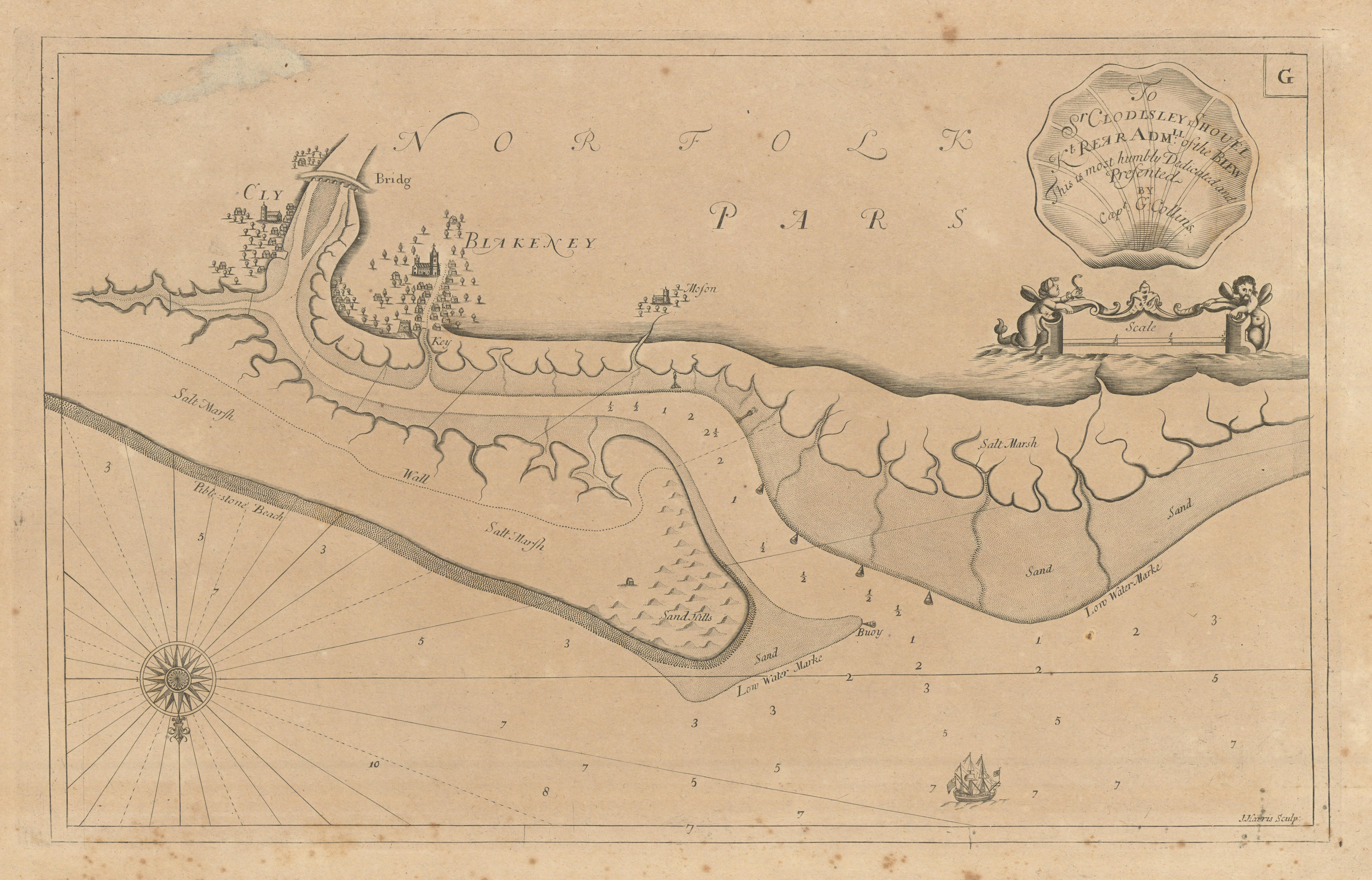
Caption below picture: '[Blakeney & environs] - To Sr. Clodlsley Shouel Kt, Rear Admll. Of the Blew this is most humbly dedicated and presented by Capt. G Collins'
This attractive navigational chart shows Blakeney, Blakeney Point and the adjacent coastline. Morston and Cley-next-the-Sea�are also marked. Sandbanks and ocean depths are indicated. The map is orientated towards the south.
DATE PRINTED: 1693 (First edition)
IMAGE SIZE: Approx 29.0 x 46.0cm, 11.5 x 18 inches (Large)
ARTIST/CARTOGRAPHER/ENGRAVER: Captain Greenvile (or Greenville) Collins. Collins was an officer of the Royal Navy and prominent hydrographer, who was commissioned by King Charles II in 1676 and appointed by Samuel Pepys (then Secretary to the Admiralty), to chart the coasts of Great Britain. The resulting atlas - Great Britain's Coasting Pilot - was the first original sea atlas to be produced by an Englishman. Prior to publication of these maps, nautical charts were often defective, and there was no centralised system for collecting and disseminating the better maps made by experienced seamen. In 1681, Collins gained the king's preferment to survey the country's coasts. The Admiralty supplied Collins with the 8-gun yacht HMS�Merlin for the first two years and later the yacht HMS�Monmouth until 1686. His work was carried out under the supervision of Trinity House, who also supported the project financially. Samuel Pepys insisted that Collins be made a younger brother of Trinity House. Collins spent seven years on the survey, the first edition of which was published in 1693, as "Great Britain's Coasting Pilot". The charts, while not completely accurate, were an enormous advance on anything before them, entitling Collins to rank as not only one of the earliest, but also among the best of English hydrographers. Twenty-one further editions were published during the eighteenth century.
PROVENANCE: "Great Britain's Coasting Pilot: being a new and exact survey of the sea-coast of England and Scotland from the river of Thames to the westward and northward; with the islands of Scilly and from thence to Carlile...", by Captain Greenvile Collins, Hydrographer in Ordinary to the King and Queen's most Excellent Majesties. London: printed by Freeman Collins, and are to be sold by Richard Mount Bookseller, at the Postern on Tower-Hill, 1693
TYPE: Decorative antique eighteenth century copperplate nautical sea chart, printed on thick paper
VERSO: There is nothing printed on the reverse side, which is plain
CONDITION: Good; suitable for framing. However, please note: Spot; Light spotting in margin. Surface paper deposit adjacent to top left border. Please check the scan for any blemishes prior to making your purchase. Please contact us if you would like to arrange to view this map. Virtually all antiquarian maps and prints are subject to some normal aging due to use and time which is not obtrusive unless otherwise stated. I offer a no questions asked return policy - see below.
AUTHENTICITY: This is an authentic historic print, published at the date stated above. I do not offer reproductions. It is not a modern copy. The term 'original' when applied to a print means that it was printed at the first or original date of publication; it does not imply that the item is unique. 'Print' means any image created by applying an inked block to paper or card under pressure by any method including wood engraving, steel engraving, copperplate, wood cut and lithography.
REMARKS: FRANCE: Gravures et Cartes anciennes. DEUTSCHLAND: Alte Lankarten und Stadt ansichten. ITALIA: Stampe e Mappe antiche. ESPA�A: Mapas antiquos y impresiones antiguas. E and OE. Force Majeure. English law shall apply.
RETURNS POLICY: I offer a no questions returns policy. All I ask is that you pay return shipping and mail back to me in original condition, suitably packed & insured, within 14 days of receipt.