Carte de l'Europe avant l'invasion des barbares, vers l'an 350 // Carte de l'Europe apr�s l'invasion des barbares, vers le fin du 5e Siecle [Europe before the invasion of the Barbarians, around the year 350 // Europe after the invasion of the barbarians, towards the end of the 5th Century]
Large (folio) antique atlas map with original hand colour, 1830
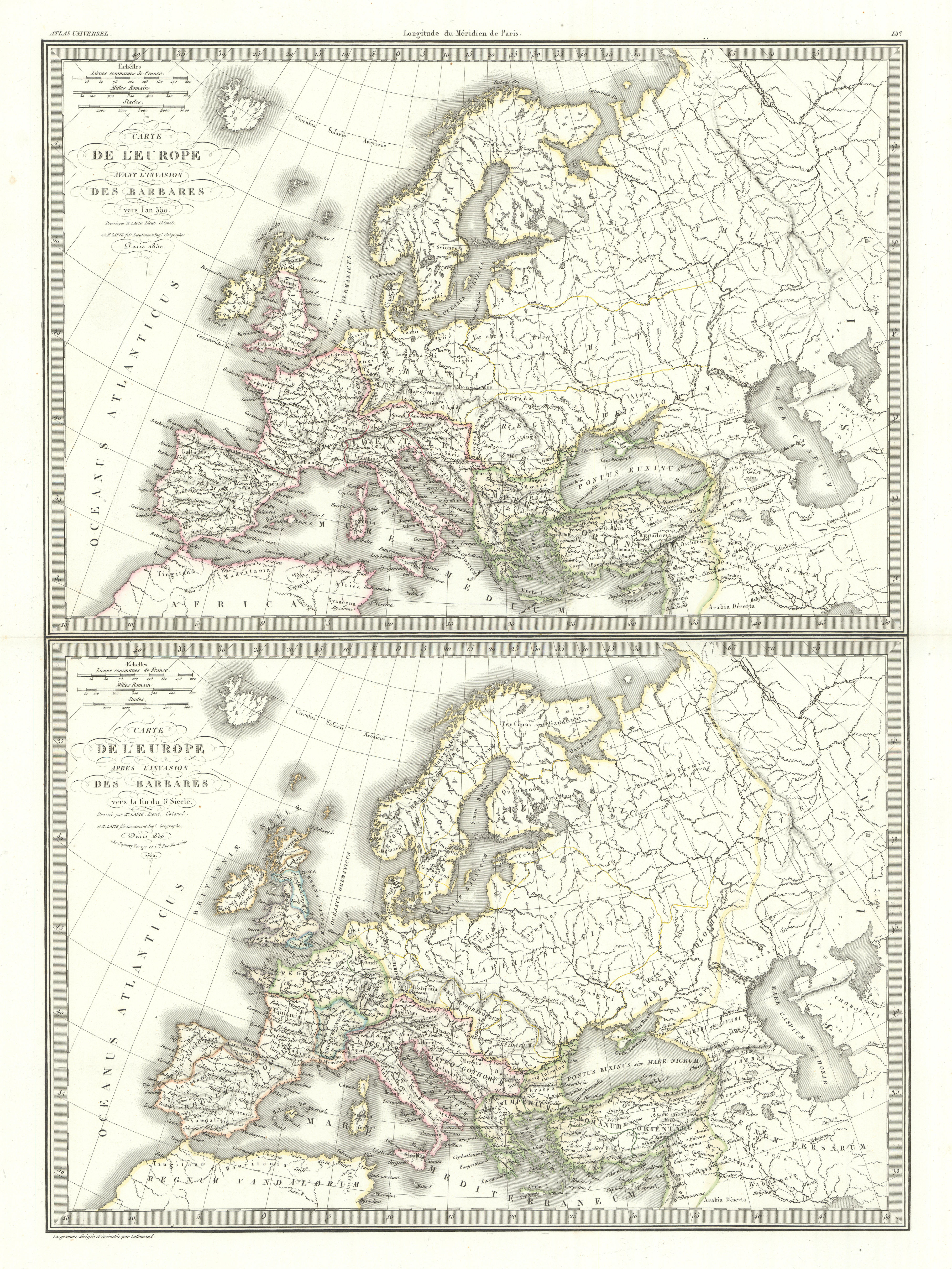
Caption below picture: 'Carte de l'Europe avant l'invasion des barbares, vers l'an 350 // Carte de l'Europe apr�s l'invasion des barbares, vers le fin du 5e Siecle [Europe before the invasion of the Barbarians, around the year 350 // Europe after the invasion of the barbarians, towards the end of the 5th Century]'
DATE PRINTED: The publication date of the atlas within which this map was printed is stated on the title page as 1829, however the publication dates as printed on the individual maps within the volume vary from 1828 to 1836. The date of first publication of this map in the state shown is 1830 (this date is printed on the map), however the date of printing is likely to have been 1836
IMAGE SIZE: Approx 63.5 x 50.0cm, 25 x 19.5 inches (Large); Please note that this is a folding map.
ARTIST/CARTOGRAPHER/ENGRAVER: Pierre Lapie, and Alexandre Emile Lapie (fils)
PROVENANCE: "Atlas Universel de Geographie Ancienne et Moderne", Par M. Lapie et M. Lapie Fils. D�di� au Roi. Paris. Eymery, Fruger et Cie., Librairies-Editeurs, Rue Mazarine, No 30.
TYPE: Large (folio) antique atlas map with original hand colour
VERSO: There is nothing printed on the reverse side, which is plain
CONDITION: Good; suitable for framing. Some of these maps have been blindstamped by the publisher as usual "Atlas Universel de Geographie (Lapie)" and the initials "EFB" of the publishers Eymery, Fruger & Brunet. Please check the scan for any blemishes prior to making your purchase. Virtually all antiquarian maps and prints are subject to some normal aging due to use and time which is not obtrusive unless otherwise stated. I offer a no questions asked return policy - see below.
AUTHENTICITY: This is an authentic historic print, published at the date stated above. I do not offer reproductions. It is not a modern copy. The term 'original' when applied to a print means that it was printed at the first or original date of publication; it does not imply that the item is unique. 'Print' means any image created by applying an inked block to paper or card under pressure by any method including wood engraving, steel engraving, copperplate, wood cut and lithography.
REMARKS: FRANCE: Gravures et Cartes anciennes. DEUTSCHLAND: Alte Lankarten und Stadt ansichten. ITALIA: Stampe e Mappe antiche. ESPA�A: Mapas antiquos y impresiones antiguas. E and OE. Force Majeure. English law shall apply.
RETURNS POLICY: I offer a no questions returns policy. All I ask is that you pay return shipping and mail back to me in original condition, suitably packed & insured, within 14 days of receipt.