Underground Map of London [Print code 419-25000-3/4/24]
Antique London Underground system map, 1924
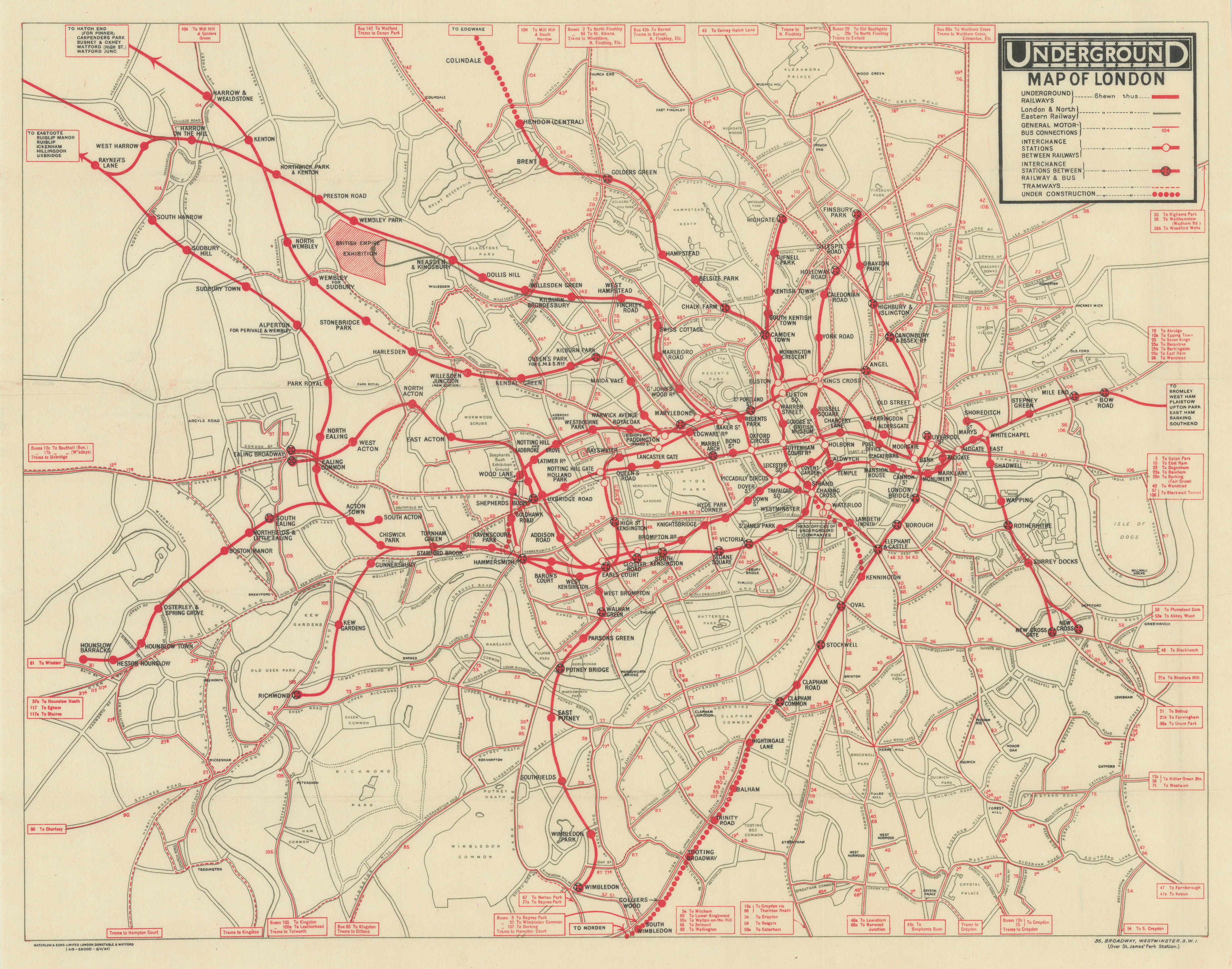
Caption below picture: 'Underground Map of London [Print code 419-25000-3/4/24]'
This is a paper edition of the geographic style Underground map. It shows all the Underground Group railways plus the Metropolitan Railway. All Underground lines are marked in red and the LNER line to the British Empire Exhibition at Wembley is marked with a thick grey line. Stations which are not covered within the boundary of the map are indicated by text boxes at the end of each line. Motor Bus and Tram routes are represented by thin red lines (tram lines are dashed), with the route number marked. Text boxes indicate the continuation of bus and tram lines beyond the border of the map. Geographical features such as roads, parks and rivers are shown in grey. Interchanges are marked by black circles with red crosses, but white line interconnectors are not used, station names are all printed in black. Railways under construction are represented as dotted lines, as used on the Hampstead & Highgate line between Charing Cross and Kennington, on the City & South London Railway extension to Morden, and the Hampstead and Highgate line extension to Edgware (Colindale Station opened August 1924). This map also marks the proposed joint extension of the Central London Railway and the LSWR between Shepherds Bush and Ravenscourt Park. City Road Station is no longer shown after its closure. South Kentish Town station is shown prior to its closure in June 1924. On the City & South London Railway (now Northern Line) under construction to Morden, the station south of Clapham Common - opened as Clapham South - is named as Nightingale Lane.
DATE PRINTED: April 1924
IMAGE SIZE: Approx 35.0 x 44.5cm, 13.75 x 17.5 inches (Large); Please note that this is a folding map.
ARTIST/CARTOGRAPHER/ENGRAVER: London Underground Railways. Map printed by Waterlow & Sons Limited, London, Dunstable & Watford
PROVENANCE: "London - Guide No. 3 - A guide to the Public Buildings, Parks, Gardens and Riverside", Published for London's Underground by Odhams Press Ltd., Long Acre, WC2. Waterlow & Sons Limited, London, Dunstable & Watford
TYPE: Antique London Underground system map
VERSO: There is nothing printed on the reverse side, which is plain
CONDITION: Good; suitable for framing. Fine condition. Please check the scan for any blemishes prior to making your purchase. Please contact us if you would like to arrange to view this map. Virtually all antiquarian maps and prints are subject to some normal aging due to use and time which is not obtrusive unless otherwise stated. I offer a no questions asked return policy - see below.
AUTHENTICITY: This is an authentic historic print, published at the date stated above. I do not offer reproductions. It is not a modern copy. The term 'original' when applied to a print means that it was printed at the first or original date of publication; it does not imply that the item is unique. 'Print' means any image created by applying an inked block to paper or card under pressure by any method including wood engraving, steel engraving, copperplate, wood cut and lithography.
REMARKS: FRANCE: Gravures et Cartes anciennes. DEUTSCHLAND: Alte Lankarten und Stadt ansichten. ITALIA: Stampe e Mappe antiche. ESPA�A: Mapas antiquos y impresiones antiguas. E and OE. Force Majeure. English law shall apply.
RETURNS POLICY: I offer a no questions returns policy. All I ask is that you pay return shipping and mail back to me in original condition, suitably packed & insured, within 14 days of receipt.