'St. Georges Feildes Southwark. The manor of Old Paris Garden in 1627. Reduced one Third in Size from the Plan in Possession of the Copyholders'
Antique colour map, 1627 (1881)
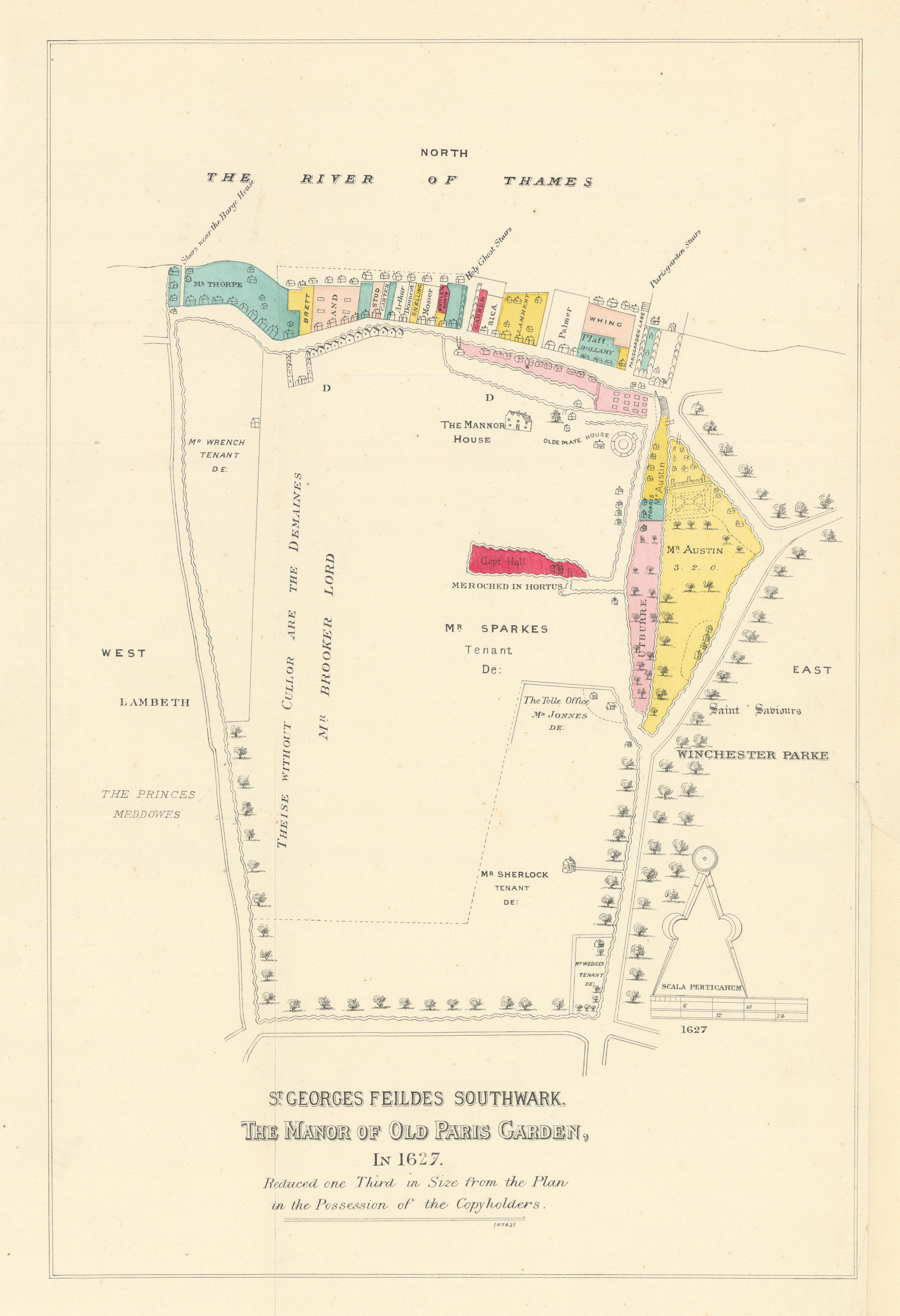
Caption below picture: 'St. Georges Feildes Southwark. The manor of Old Paris Garden in 1627. Reduced one Third in Size from the Plan in Possession of the Copyholders'
This map by local historian and resident William Joseph Meymott shows the the Manor of Paris Garden, Southwark, as it was in 1627. The Manor is roughly coincident with the parish of Christ Church, has been a well-defined area from the early mediaeval period. It was bounded on the north by the Thames and on the other three sides by a stream or open sewer which ran in a wide loop round the manor from the Old Barge House Stairs, south to what is now Surrey Row, and north again to the river near Falcon Dock (now just west of the Tate Modern). The stream may have been in part a natural feature, though it is unlikely that it was so for the whole of its length, but the earth wall which flanked it was certainly man-made. Until the mid 20th century, this survived as a street named Broadwall, since redeveloped. The map shows the "Olde Paye House", a round structure close to the Manor House. This building was the Swan theatre, built in 1595 on top of a previously standing structure, during the first half of William Shakespeare's career; its form would have been similar to today's reconstructed Globe Theatre
DATE PRINTED: 1627 (1881)
IMAGE SIZE: Approx 34.5 x 23.5cm, 13.5 x 9.25 inches (Large); Please note that this is a folding map.
ARTIST/CARTOGRAPHER/ENGRAVER: William Joseph Meymott
PROVENANCE: "An Historical Account of the Parish of Christ Church Surrey" by William Joseph Meymott, Steward of the Manor. Printed for private circulation
TYPE: Antique colour map
VERSO: There is nothing printed on the reverse side, which is plain
CONDITION: Good; suitable for framing. Short marginal tear in right edge at fold, repaired verso. The lower right margin has been restored. Please check the scan for any blemishes prior to making your purchase. Virtually all antiquarian maps and prints are subject to some normal aging due to use and time which is not obtrusive unless otherwise stated. I offer a no questions asked return policy - see below.
AUTHENTICITY: This is an authentic historic print, published at the date stated above. I do not offer reproductions. It is not a modern copy. The term 'original' when applied to a print means that it was printed at the first or original date of publication; it does not imply that the item is unique. 'Print' means any image created by applying an inked block to paper or card under pressure by any method including wood engraving, steel engraving, copperplate, wood cut and lithography.
REMARKS: FRANCE: Gravures et Cartes anciennes. DEUTSCHLAND: Alte Lankarten und Stadt ansichten. ITALIA: Stampe e Mappe antiche. ESPA�A: Mapas antiquos y impresiones antiguas. E and OE. Force Majeure. English law shall apply.
RETURNS POLICY: I offer a no questions returns policy. All I ask is that you pay return shipping and mail back to me in original condition, suitably packed & insured, within 14 days of receipt.